Eastern California's intense seismic and geothermal activity: Chicken or egg?
A 13 May M=3.5 quake struck 30 mi (50 km) west of Death Valley at the northern tip of the Ash Hill fault. This quake is anything but an outlier: The 'Walker Lane' that extends between the eastern crest of the Sierra Nevada and into western Nevada was the site of the state's third largest historical earthquake, in 1872, as well as some of the most vigorous seismic sequences in California since 1980. The Walker Lane accommodates 10-13 mm per year (0.5 in/yr) of right-lateral motion, about half of the San Andreas slip (Wesnousky, 2005), so by any measure is a major player in the Pacific-North American plate boundary.
 A decade of seismicity reveals the strangely symmetrical distribution of earthquake clusters located beyond the ends of the 1872 Mw~7.6 earthquake. Both clusters enclose mixtures of hot springs, and extensional ('normal') faults and strike-slip faults, as well as sporadic eruptions in the past 12,000 or so years. Because of the hot springs, both have geothermal power plants. Several M>6 shocks struck in the 1980's in the northern cluster, and several M~5 quakes struck in the 1990's in the southern cluster.
 The quake is a reminder that, despite all the press, California's seismic hazard is not confined to the San Andreas. At the dawn of the plate tectonic revolution, the great Tanya Atwater first unraveled the 10 million year evolution of the San Andreas. Looking ahead to the next 10 million years, she argues that the Owens Valley and Death Valley faults will retire the San Andreas, as the plate boundary continues migrating to the East.
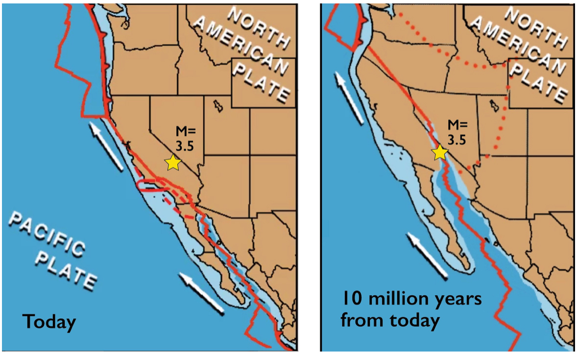 Here are two frames from an animation by Tanya Atwater, Professor Emeritus at U.C. Santa Barbara. The 13 May M=3.5 quake is one small step along the road to a vast transformation of the Pacific-North America plate boundary. Eventually, all of California will be head north toward Alaska, rather than only today's coastal sliver of liberals. See https://youtu.be/9F8AcDJq2QU
 Was the 1872 rupture hemmed in by the geothermal zones, or did the rupture turn on the seismicity and hot water in these zones?
The 1872 rupture might reasonably have been confined between these two perhaps mushy, shattered, fluid-saturated zones. Or, these zones could have been turned on by the 1872 earthquake. This chicken-or-egg riddle would be easy to answer this if we knew whether or not the quake rate in these zones increased after the 1872 shock, but the mainshock predates seismometers, and few lived there.
Only one quake is known in the entire area before 1872, a M~5.5 event in July 1871 at the southern tip of the Owen's Valley fault, shown as a star in the first map. This suggests the clusters might have been active before the mainshock. On the other hand, one of the two largest aftershocks of the 1872 event, a M~6.8 two weeks after the mainshock, stuck in the center of the northern cluster near Bishop (both are from Toppozada, Real, and Parke, 1981), also shown on the map. So, this would support the clusters being turned on by the mainshock. We walk away with a tie.
However, there is another clue to the riddle. The clusters lie in lobes where the 1872 rupture increased the shear stress and unclamped strike-slip faults. So, faults in the red zones below are brought closer to failure; in the blue zones they are inhibited from failure. This is called the 'Coulomb failure stress;' we made the calculation below in our free research software, Coulomb 3.4 (Shinji Toda et al., 2011).
 Most of the past decade of shocks—but not last week's M=3.5 event—lie in the Coulomb trigger zones imparted by the 1872 quake (the stresses are calculated using a reasonable but uncertain model of the rupture, based on the field mapping of the late and gifted Sarah Beanland and Malcolm Clark, 1994). The Coulomb trigger zones encompass the quakes beyond the ends of the 1872 rupture, and to a lesser extent, those extending to the east and west. But could stresses imparted 145 years ago still play a role today, or is this a phantom correlation?
 Another way to assess the problem is to see if such intense off-fault clusters are found at other sites with geothermal activity. No better place to hunt for this than Iceland, with abundant earthquakes, eruptions, and geothermal power. The beautifully recorded 2008 Mw=6.0 South Iceland earthquake (Brandsdóttir et al., 2010; Decriem et al., 2010) shows clusters of aftershocks off the ends of the main rupture resembling Eastern California.
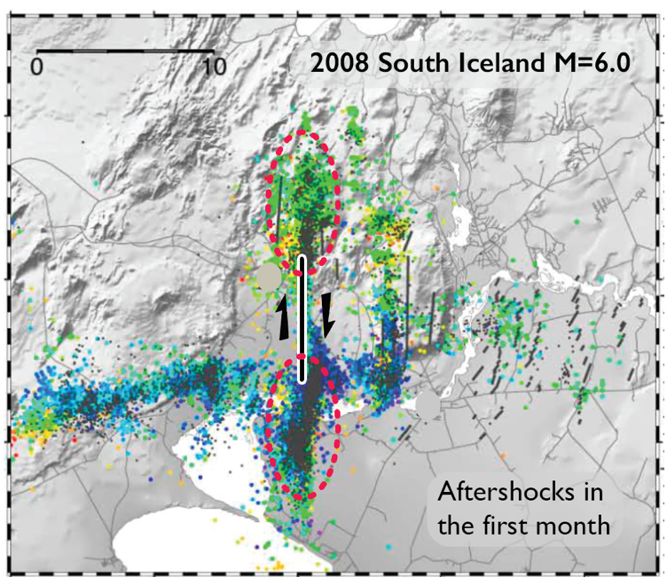 The figure is modified from Brandsdóttir et al. (2010), based on the fault inferred by Decriem et al. (2010). The aftershocks do indeed look like a small-scale version of contemporary seismicity surrounding the 1872 quake. The red ellipses enclose intense aftershock activity.
 Could aftershocks persist for 150 years?
Even if the 1872 rupture triggered the activity in the clusters, it just begs a harder question: Could aftershocks continue almost 150 years after a mainshock? In fact, that question is very much alive in the New Madrid, Missouri, area, the site of vigorous seismicity today that some researchers think could be aftershocks of the still older 1811-1812 quakes, which were about the same size as the 1872 event.
What both sites have in common are active but slowly slipping faults; the Owens Valley fault slips at 2-3 mm/yr, about a tenth of the San Andreas rate. This means that at the aftershock sequence should be about ten times more drawn out than San Andreas aftershocks. The Owens Valley fault appears to fire off M~7.5 shocks roughly every 3,000-4,000 years (Lee et al., 2001), and so 150 years is several percent of the time between quakes, equivalent to about 15 years on the San Andreas, which is perhaps reasonable.
 Owen's Valley and Lone Pine buildings collapsed in 1872, courtesy of Laws Railroad Museum.
 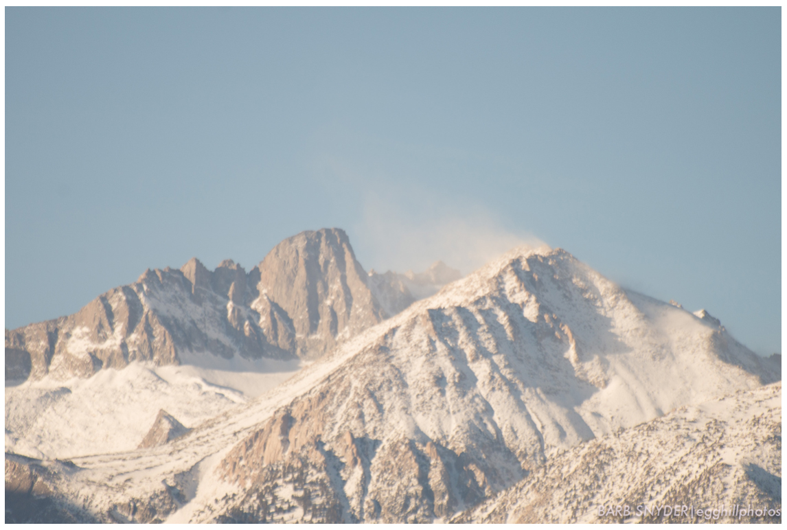 We owe the Sierran crest to the Lone Pine and Independence faults that bound the eastern Sierras from Owens Valley. (Photo by Barb Snyder, Egghillphotos, 2014)
 So, what is the role of the Owens Valley, Lone Pine, and Death Valley faults?
These extensional-right lateral faults, along with others to the north and south, lift up the highest peaks and depress the deepest valleys in California. Take away the faults, and we'd lose both Mount Whitney and Death Valley. Give these faults a little time, and they will bound the vast Pacific and North American plates.
Ross Stein, Lester Lubetkin, and Volkan Sevilgen
You can check your home's seismic risk at Temblor
Data from USGS, Nevada Seismological Laboratory (Univ. Nevada Reno), Tanya Atwater, and:
Sarah Beanland and Malcolm M. Clark (1994), The Owens Valley fault zone, eastern California, and surface faulting associated with the 1872 earthquake, U.S. Geol. Surv. Bulletin 1982, 29 p.
Bryndís Brandsdóttir, Parsons, M. and White, R. S. and Guðmundsson, O. and Drew, J. and Thorbjarnadóttir, B. (2010) The May 29 2008 earthquake aftershock sequence within the South Iceland Seismic Zone: Fault locations and source parameters of aftershocks. Jokull: journal of the glaciological and geological societies of Iceland, 60. pp. 23-46. ISSN 0449-0576
Judicael Decriem, T. Arnadottir, A. Hooper, H. Geirsson, F. Sigmundsson, M. Keiding, B. G. Ofeigsson, S. Hreinsdottir, P. Einarsson, P. LaFemina and R. A. Bennett (2010), The 2008 May 29 earthquake doublet in SW Iceland, Geophys. J. Int. 181, 1128–1146, doi: 10.1111/j.1365-246X.2010.04565.x
Jeffrey Lee, Joel Spencer, Lewis Owen (2001), Holocene slip rates along the Owens Valley fault, California: Implications for the recent evolution of the Eastern California Shear Zone, Geology, 29, 819–822.
Shine Toda, Ross S. Stein, Volkan Sevilgen, and Jian Lin (2011), Coulomb 3.3 Graphic-rich deformation and stress-change software for earthquake, tectonic, and volcano research and teaching-user guide. U.S. Geol. Surv. Open-File Rep. 2011-1060, ix, 54 p. (http://pubs.usgs.gov/of/2011/1060/)
Tousson R. Toppozada, C. R. Real, and D. L. Parke (1981). Preparation of isoseismal maps and summaries of reported effects for pre-1900 California earthquakes, Calif. Div. Mines Geol. Open-File Rept. 81-11 SAC, 182 pp (Interactive historical earthquake map, http://maps.conservation.ca.gov/cgs/historicearthquakes/
Steven G. Wesnousky (2005), Active faulting in the Walker Lane, Tectonics, 24, doi:10.1029/2004TC001645.
--

__._,_.___
No comments:
Post a Comment