Mt. Barujari, Rinjani erupts in Lombok, trekkers evacuated

The volcano Mt. Barujari on the island of Lombok, just east of Bali, reportedly erupted Sunday morning at approximately 10:45 am local time.
The active volcano is situated right in the east side of the caldera of Lombok's popular trekking mountain Rinjani. It's nine kilometers or about a 12 hour climbing trip up, said Mutaharlin, chairman of the Rinjani Volcano Observation Post, in the village of Sembalun. "We've already set the alert status from the normal level," he told Tempo on Sunday.
The head of Sembalun Resort, Mt. Rinjani National Park (TNGR), Zulfahri, said from Mataram that the island is still experiencing smoke and dust fall on a small scale after the eruption.
"The condition of the smoke at the beginning of the eruption was not too big, but we have made efforts to evacuate the climbers for fear the eruption continues to expand," Zulfahri said, as quoted by Republika.
He said he did not know the exact number of climbers that were still at Lake Segara Anak, Rinjani's crater lake.
"There are four members of the TNGR team still up (on the slopes) to evacuate the climbers. I am not yet exactly sure how many climbers are registered, but the data will make everything more clear," Zulfahri explained yesterday.
The evacuation was apparently being routed through a climbing lane in Torean, North Lombok, which hasn't been hit as hard with smoke and dust from the eruption.
Zulfahri confirmed that the official hiking trails through Sembalun and Timbanuh, in East Lombok and Senaru in North Lombok have all been closed.
"Ascent activity has been closed because the conditions do not allow for the safety of the climbers and this information has been conveyed to tour guides via the internet," he said.
TNGR has also contacted the organizers of the event "Mulang Pekelem," a two-day religious upacara (ceremony) on Rinjani's slopes.
Mt. Barujari's last reported eruption was on May 2, 2009 with a death toll of 31 people, due to floods resulting from the eruption. The mountain previously erupted in 2004 but thankfully no casualties then. Other recorded eruptions were in 1944, 1966, 1994.
First and foremost, we sure hope everyone's ok. We also hope this doesn't screw around too much with flights like Raung did earlier this year.
http://bali.coconuts.co/2015/10/26/mt-barujari-rinjani-erupts-lombok-trekkers-evacuated
_______________________________________________________________________________
Volcanic activity worldwide 26 Oct 2015: Soputan volcano, Dukono, Turrialba, Tungurahua, Batu Tara, ...

")
")
")


An ash plume rose approx. 1.5 km above the Nakadake crater and dissipated quickly. Alert level remains at 3 out of 5, and an exclusion zone of 2 km around the crater is in place.
Bagana (Bougainville Island, Papua New Guinea): Ash emissions occurred from the volcano yesterday, suggesting ongoing mild explosive activity. VAAC Darwin reported a low-level plume extending 50 km northwest from Bagana.
Batu Tara (Sunda Islands, Indonesia): A volcanic ash plume at 5,000 ft (1.5 km) altitude extending 80 km west of the volcano was reported by VAAC Darwin this morning.
Soputan (North Sulawesi, Indonesia): The volcano is calm at the surface, but seismic activity shows it is at unrest and might erupt again soon.
Our correspondent Andi visited the volcano observatory during our ongoing tour to N-Sulawesi and Halmahera: "Deep volcanic quakes (5-10 km depth) and shallow tremors has been more frequent (10 -15 times per day) since 3 oct - 22 oct. This suggests there is probably magma raising up slowly, but there are still no glowing spots visible."
Dukono (Halmahera): The volcano continues to erupt continuous, loud, roaring jets of gas and small amounts of spatter from vents at the bottom of the deep crater.
Ash plumes are regularly being reported by VAAC Darwin.
The attached pictures by our friend Aris Yanto was taken a few days ago from the crater rim.
Turrialba (Costa Rica): After several months of relative calm, the volcano began to erupt ash plumes again since 23 Oct. Some of the explosions have been relatively strong and caused very small pyroclastic flows limited to the crater area.
The origin of these emissions are likely phreatic explosions, i.e. caused by overheated ground water flashing to steam.
Whether this is the case or at least some fresh magma is involved is unclear. Seismic activity, which could suggest the rise of new magma, has been reported to have picked up recently.
Cotopaxi (Ecuador): No significant changes have occurred during the past days. The activity remains characterized by intense degassing and occasional mild ash emissions mixed into the plume.
Tungurahua (Ecuador): Mild to moderate ash emissions, with ash plumes rising 1-2 km above the crater, have become more frequent over the past days, suggesting the volcano's activity has started to picking up. An explosion at 04:33 yesterday morning was seen ejecting incandescent material that rolled down the western flank to up to 1 km distance.
Light ash fall occurred later in Chacauco, Cotaló and Manzano. The ash was reported to be black and red in color and sugary in grain size. The first (color) suggest that it is from new magma (as opposed to typically gray-brown colored ash from pulverized older rock). The volcano observatory also reported an increase in seismic activity associated with fluid movements.
One possibility is that the volcano (after all, one of the world's most active ones) enters a more vigorous phase of activity in the near future, as often occurred in the past.
Volcano Activity Summary for 26 Oct 2015:
Currently erupting:
Ambrym (Vanuatu): active lava lakes in several craters (updated 24 May 2015)Aso (Kyushu): steaming, occasional phreatomagmatic or strombolian explosions (updated 26 Oct 2015)
Bagana (Bougainville Island, Papua New Guinea): mild ash emissions (updated 26 Oct 2015)
Batu Tara (Sunda Islands, Indonesia): strombolian explosions, ash plumes up to 500 m, extrusion of a small lava dome with rockfalls (updated 26 Oct 2015)
Colima (Western Mexico): intermittent explosions from summit crater (updated 20 Oct 2015)
Cotopaxi (Ecuador): vulcanian explosions (updated 16 Aug 2015)
Dukono (Halmahera): thermal anomaly, probably small explosive activity in summit crater (updated 26 Oct 2015)
Erebus (Antarctica): active lava lake in summit crater (updated 8 Dec 2014)
Erta Ale (Ethiopia): active lava lake in northern pit crater, active hornito with intermittend flow in southern crater (updated 11 Jan 2013)
Fuego (Guatemala): lava fountaining, strong strombolian activity, lava flows (updated 16 Oct 2015)
Gamalama (Halmahera): new eruption on 18 Dec 2014 (updated 8 Sep 2015)
Ibu (Halmahera, Indonesia): stromolian and phreatomagmatic explosions (updated 14 Nov 2014)
Karangetang (Siau Island, Sangihe Islands, Indonesia): lava flow, incandescent avalanches (updated 21 Oct 2015)
Karymsky (Kamchatka): occasional small explosions, thermal anomaly (updated 20 Oct 2015)
Kilauea (Hawai'i): new lava flow from vents on NE flank of Pu'u 'O'o (updated 28 Apr 2015)
Kliuchevskoi (Kamchatka): ash emissions, weak strombolian activity (updated 11 May 2015)
Manam (Papua New Guinea): large explosion on 31 July 2015 (updated 31 Aug 2015)
Nevado del Ruiz (Colombia): intermittent ash emissions, strong degassing (updated 21 Sep 2015)
Nishino-shima (Volcano Islands, Japan): growing island (updated 21 Oct 2015)
Nyiragongo (DRCongo): active lava lake in summit crater (updated 26 Feb 2014)
Ol Doinyo Lengai (Tanzania): effusion of natrocarbonatite lava inside the crater (updated 8 Jul 2013)
Pacaya (Guatemala): weak strombolian activity in summit crater (updated 18 Aug 2015)
Popocatépetl (Central Mexico): degassing, sporadic explosions, slowly growing lava dome (updated 18 Aug 2015)
Rabaul (Tavurvur) (New Britain, Papua New Guinea): lava fountains, ash emissions from Tavurvur cone (updated 12 Sep 2014)
Reventador (Ecuador): lava flow on SW flank (updated 17 Aug 2015)
Sakurajima (Kyushu, Japan): seismic swarm, eruption warning (updated 23 Oct 2015)
Sangay (Ecuador): likely strombolian eruptions at summit crater (updated 13 Mar 2015)
Santiaguito (Guatemala): slowly growing lava dome, ash explosions, viscous lava flow extrusion, occasional pyroclastic flows (updated 1 Oct 2015)
Semeru (East Java, Indonesia): growing lava dome, lava flow, strombolian activity (updated 16 Jun 2015)
Shiveluch (Kamchatka): growing lava dome (updated 23 Oct 2015)
Sinabung (Sumatra, Indonesia): continuing pyroclastic flows (updated 20 Oct 2015)
Stromboli (Eolian Islands, Italy): weak strombolian activity at summit vents (updated 16 Apr 2015)
Suwanose-jima (Ryukyu Islands): strombolian explosions in Ontake crater (updated 1 Oct 2015)
Telica (Nicaragua): intermittent phreatic explosions (updated 27 Sep 2015)
Tungurahua (Ecuador): intermittent small ash emissions, small to moderate explosions (updated 26 Oct 2015)
Turrialba (Costa Rica): small to moderate ash emissions, intense degassing (updated 26 Oct 2015)
Villarrica (Central Chile): small lava lake in summit crater (updated 12 May 2015)
Yasur (Tanna Island, Vanuatu): ash emissions, weak strombolian explosions (updated 14 Aug 2013)
Eruption warning / minor activity:
Alaid (Northern Kuriles): probable strombolian activity in summit crater (updated 8 Oct 2015)Asama (Honshu): occasional small explosions since 16 June 2015 (updated 22 Jun 2015)
Augustine (Cook Inlet (SW Alaska))
Barren Island (Indian Ocean): weak thermal hot spot (updated 19 Aug 2015)
Bezymianny (Central Kamchatka Depression): steaming, weak seismic activity (updated 3 Jul 2014)
Bulusan (Luzon Island, Philippines): occasional phreatic explosions (updated 16 Jun 2015)
Chirinkotan (Northern Kuriles): sporadic ash emissions (updated 28 Jul 2015)
Copahue (Chile/Argentina): intermittent ash emissions, strong degassing, crater incandescence (updated 18 Oct 2015)
Etna (Sicily, Italy): sporadic weak ash emissions from New SE crater (updated 19 Apr 2014)
Heard (Australia, Southern Indian Ocean): possibly lava lake in summit crater (updated 5 Dec 2014)
Kavachi (Solomon Islands): no eruption since 2007 (updated 16 Jun 2014)
Kerinci (Sumatra): seismic unrest, steam emissions (updated 5 Jun 2013)
Kick 'em Jenny (West Indies, Grenada): volcanic unrest, eruption warning (updated 24 Jul 2015)
Krakatau (Sunda Strait, Indonesia): steaming, seismic unrest (updated 31 Mar 2014)
Kuchinoerabu-jima (Ryukyu Islands): large explosive eruption on 29 May 2015 (updated 27 Mar 2015)
Lokon-Empung (North Sulawesi, Indonesia): small explosions, lava flow? (updated 31 Aug 2015)
Lopevi (Vanuatu): eruption warning (updated 16 Dec 2014)
Mayon (Luzon Island): steaming (updated 18 Dec 2014)
Merapi (Central Java, Indonesia): sporadic phreatic explosions (updated 21 Aug 2015)
Michael (United Kingdom, South Sandwich Is): unspecified activity detected as hot spot on satellite data (updated 3 Oct 2015)
Nyamuragira (DRCongo): active lava lake (updated 29 Nov 2014)
Ontake-san (Honshu): steaming, low seismic activity (updated 18 Dec 2014)
Papandayan (West Java): steaming (updated 6 May 2013)
Pavlof (Alaska Peninsula, USA): steaming, elevated seismic activity (updated 22 Dec 2014)
Piton de la Fournaise (La Réunion): eruption seems to have ended 18 Oct (updated 25 Oct 2015)
Poas (Costa Rica): phreatic explosions (updated 14 Oct 2014)
Rasshua (Central Kuriles)
Raung (East Java): intra-caldera eruption with lava flow and strombolian activity (updated 27 Aug 2015)
Rincón de la Vieja (Costa Rica): phreatic explosions from crater lake (updated 21 Sep 2014)
Rinjani (Lombok): small explosion on 25 Oct 2015 (updated 25 Oct 2015)
Sabancaya (Peru): steaming, elevated seismic activity (updated 11 Oct 2015)
Sacabaya (Northern Chile, Bolivia and Argentina)
San Cristobal (Nicaragua): possible ash emission on 11 April (updated 9 Mar 2015)
San Miguel (El Salvador): degassing, seismic unrest, sporadic ash emissions (updated 28 Jan 2015)
Sangeang Api (Indonesia): steaming, possibly weak lava extrusion at summit (updated 24 Aug 2015)
Shishaldin (United States, Aleutian Islands): mild explosive activity, intermittent more intense phases (updated 4 Sep 2015)
Sirung (Pantar Island, Indonesia ): degassing (updated 10 Jul 2015)
Slamet (Central Java): steam emissions (updated 12 Jan 2015)
Soputan (North Sulawesi, Indonesia): seismic unrest (updated 26 Oct 2015)
Ubinas (Peru): occasional explosions (updated 3 Oct 2015)
Ulawun (New Britain, Papua New Guinea): degassing, ash venting (updated 5 Aug 2013)
Zhupanovsky (Kamchatka, Russia): intermittent ash emissions (updated 22 Jun 2015)
http://www.volcanodiscovery.com/volcano-activity/news/55101/Volcanic-activity-worldwide-26-Oct-2015-Soputan-volcano-Dukono-Turrialba-Tungurahua-Batu-Tara-.html
Descending Into A Volcano — To Farm
-
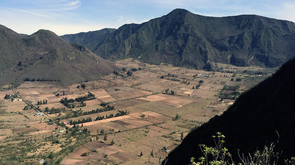 VIEW SLIDESHOW 1 of 3The Pululahua Crater in Ecuador erupted about 2,500 years ago. The soils remaining in the collapsed mountain are mineral rich and good for cultivation.Kirk Siegler NPR

From the rim of Ecuador's Pululahua Geobotanical Reserve, it's at least a 45-minute drive (no, more like plunge) down a winding, bone-crushing dirt road to the floor of the crater. But it's well worth it. After all, how often do you get to say you've traveled to what's billed as the world's only inhabited, cultivated volcano?
I should offer a caveat since volcanoes are very much in the news here. This one's inhabited because it's dormant. It last erupted about 2,500 years ago but the soils that were left behind in the collapsed mountain are rich in minerals. Today the terraced mountainsides are still excellent for cultivating crops such as corn, sugar cane, beans and a rare variety of potato called camoate.
Pululahua is loosely translated from Quechua (the indigenous language) to fog. Almost every afternoon, clouds shroud the steep mountain walls that circle the crater in a dense fog that blows in from the coast.
But if you get there early enough in the morning, it's a stunning sight. It's also a window into rural Ecuador's past. Pululahua is just a short distance from the bustling capitol of Quito, yet this crater -– protected as a geobotanical reserve in 1978 and later as a national park –- is a peaceful escape.
It's widely believed that there has been farming here for hundreds of years. But in more recent times, the crater was included as part of Ecuador's large, colonial hacienda system. The country's first Spanish colonialists divided up much of Ecuador into vast haciendas, or farms, that were powered by mostly native farm workers, or huasipongos.
Thousands of native people did the farming, without pay, in exchange for a very small piece of land they could farm on their own, usually on their one day off a week. Ecuador didn't actually abolish this huasipongo system until the land reforms of 1963.
Today, on Pululahua's pancake flat floor, a half dozen or so farms run by the descendants of these huasipongos remain. One of them is 86-year-old Humberto Moromenacho, who is one of 15 full-time residents still living in the crater.
Taking a break from work to talk outside a small shack that serves as an improvised shop, Moromenacho uses a cut, wooden log as a stool to sit on. His hands are caked with dirt from the fields and he's missing part of his index finger on his right hand.
Through an interpreter, he says that his family has farmed here for more than 300 years. All of his relatives have left though. In fact, most of the remaining people who still live in the crater full-time are elderly. Even just ten years ago, the population was 50. The last of the younger families moved away when the small school closed four years ago. There also isn't a doctor or other basic services. But aside from that, most of the farms like Moromenacho's are pretty well self-sustainable.
Moromenacho says his relatives who live nearby in San Antonio de Pichincha and the Quito area come back to help to pick his corn and tend to his beef cows. Most of the organic crops grown here are sold at markets elsewhere, the remaining is consumed locally.
Even after a short visit, you can't help but get the sense that this way of life may be going away soon. Moromenacho's relatives may sell his small piece of land when he dies if there's no one willing to keep farming it. The same dilemma will probably apply to the other indigenous farmers here. And a few of the crater's newer inhabitants -– aside from the owners of a small youth hostel –- have come from other countries more recently to set up horse ranches and more modern organic farms mostly for tourism.
Some of these spiffy, newer homes with wrap-around porches can be seen on the ascent back up the windy road to get back to Quito. But there is no time to visit. The clouds were rolling in, and soon the Pululahua crater would be engulfed in fog.
A version of this story originally appeared on NPR's On The Road Tumblr.
http://boisestatepublicradio.org/post/descending-volcano-farm
--

__._,_.___
No comments:
Post a Comment