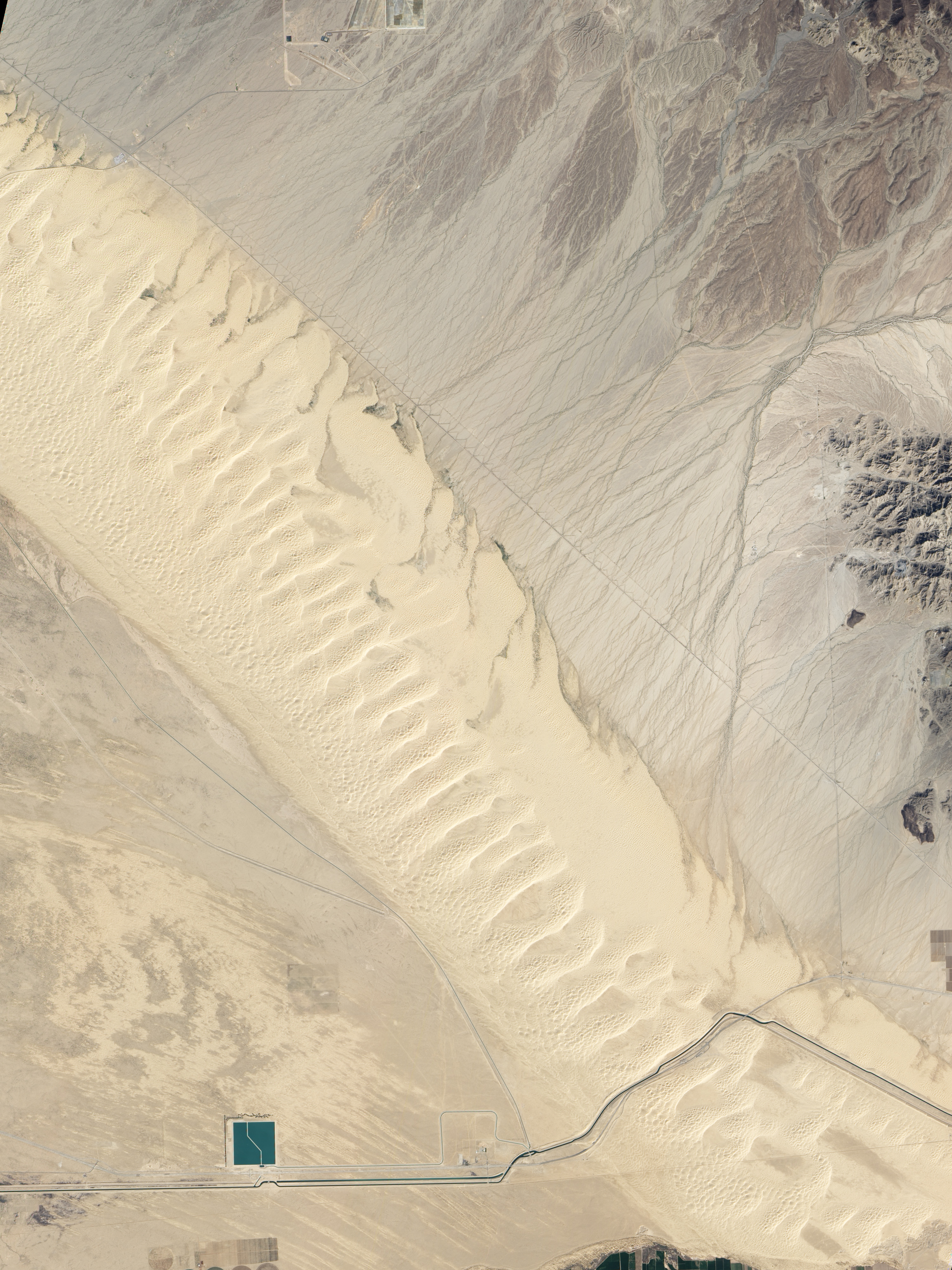
The Algodones Dunes in southeastern California include an array of formations. Four different types of sand dunes are on display in this true-color image captured by the Advanced Land Imager (ALI) on NASA's Earth Observing-1 (EO-1) satellite on February 24, 2011.
The oldest of the dunes are the large, compound crescentic dunes in the middle of the field. Compound crescentic dunes are crescent-shaped and have other dunes on top of them. The crests run diagonally, southwest to northeast. This orientation is an indication that the dunes formed earlier than others in the field, at a time when wind conditions were different. The compound crescentic dunes are between 15,000 and 18,000 years old and slowly creeping southeast.
The rest of the dunes in the image are younger. Most are simple crescentic dunes (the most common type in the world) that get their crescent shape when winds blow consistently in the same direction. These dunes are migrating toward the east-southeast. The western crescentic dunes and the crescentic dune on top of the larger compound dunes are older than the eastern sand fields, which are constantly being reshaped by water flowing from the Cargo Muchacho Mountains in the east and by the plants that grow in the waterways. (The waterways and plants are fine, dark lines in the upper right corner.)
The last type of formation, linear dunes and associated zibars, are also part of the younger generation. The linear dunes run in long lines down the western edge of the field. The zibars cross between linear dunes and likely formed from courser sand settling in the valley as the linear dunes migrate eastward.
Though the mountains of sand that make up the Algodones field could not seem more different from the irrigated green fields of the Imperial Valley a few miles to the west, the two are closely related. Both are artifacts of Lake Cahuilla, a large freshwater lake that occasionally forms in southern California. The lake fills when the Colorado River Delta clogs with silt, diverting the river to the north into the Imperial Valley. It slowly disappears when the river returns to its former course, leaving a layer of silt that provides rich farmland. The waves on the eastern shore also deposit fine sediment and sand that have formed the dune field.
References
- Derickson, D., Kocurek, G., Ewing, R.C., and Bristow, C. (2008). Origin of a complex and spatially diverse dune-field pattern, Algodones, southeastern California. Geomorphology, 99. 186-204.
- Singer, E. (n.d.) Ancient Lake Cahuilla. San Diego State University Center for Inland Waters. Accessed March 11, 2011.
- United States Geological Survey. (1997, October 29). Types of dunes. Accessed March 11, 2011.
NASA Earth Observatory image created by Jesse Allen and Robert Simmon, using EO-1 ALI data provided courtesy of the NASA EO-1 team and the United States Geological Survey. Caption by Holli Riebeek.
Source--
Got Penguins?
Penguin News Today
The Science of Penguins
Gentoo Penguins of Gars O'Higgins Station, Antarctica
Wolves & Werewolves/Science, Myth & News
http://canislupus101.blogspot.com/
http://dances-with-werewolves.blogspot.com/
http://throughgoldeneyes.blogspot.com/
__._,_.___
No comments:
Post a Comment