Rock Fall Hazards in Yosemite National Park
Much of the spectacular scenery in Yosemite is a product of glacial erosion followed by rock falls

| This illustration is part of a rockfall hazard map for Yosemite National Park. It shows recent, historic and prehistoric rock fall and rock slide areas near some of the busiest sites in the park. The National Park Service, United States Geological Survey and others are working to understand the rock fall and rock slide hazards in the park, educate park visitors, and use what they learn to make the park an even safer place to visit. Map from USGS Open-File Report 98-467. Enlarge map. |
Rock Falls and Rock Slides - Yosemite Valley
Yosemite Valley is a deep, glacier-carved valley bounded by steep granite cliffs. These steep cliffs produce numerous rock falls and rock slides every year. These events range in size from individual boulders to massive falls of several million cubic meters. Field work in the park area has documented hundreds of large falls over the past 150 years. Several of these falls have killed people in the valley.The park receives between three and four million visitors per year. Some of the rock falls and rock slides have occurrred in parts of the park that are heavily used by visitors. To reduce the potential impact of future events the National Park Service is working to understand the rock fall and rock slide hazards. Predicting rock fall events is not possible but information about how, where and why they occur can be used to improve visitor safety.
Most rock falls in Yosemite are triggered by earthquakes, rainstorms, or rapid snow melt. However, many rock falls occur without an obvious triggering event. Some are probably associated with gradual stress release and weathering of granitic rocks in the valley walls. These processes have been active enough to produce a talus slope over 100 meters thick at the base of some slopes.
Recent Rock Fall Activity
How to Survive a Rock Fall
"Rock-fall hazard zones occur throughout the park near any cliff faces. If you witness a rock fall from the Valley floor, quickly move away from the cliff toward the center of the Valley. If you are near the base of a cliff or talus slope when a rock fall occurs above, immediately seek shelter behind the largest nearby boulder. After rocks have stopped falling, move quickly away from the cliff toward the center of the Valley. Be aware that rock falls are inherently unpredictable and may happen at any time. Pay attention to warning signs, stay off of closed trails, and, if unsure, keep away from the cliffs." Quoted from the National Park Service website (link).NPS Response to Rock Fall Studies
The National Park Service is learning from their rock fall research program and using that information to make the Park a safer place to visit. After studying rock falls in the Curry Village area in 2008, the Park Service determined that over 200 tent and cabin sites were within rock fall hazard areas and closed them permanently. These studies continue in other parts of the park.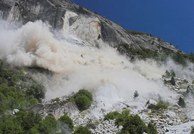
| Spectacular rock fall in Yosemite photographed by Herb Dunn on August 6, 2006. View a sequence of photos that document the fall from start to finish and read what Herb experienced while bravely taking the photos. More. |
This video by the National Park Service and Yosemite Conservancy demonstrates the rock fall and rock slide hazards in the Yosemite National Park area and explains some of the work being done to learn more about the hazards, educate visitors and reduce future impact. Click here to see the video
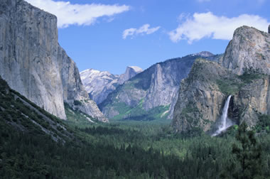
| A classic view of Yosemite Valley showing the tall, steep granite cliffs that are prone to rock falls and rock slides. This view, looking east up the Yosemite Valley shows El Capitan on the left, Half Dome in the far distance and Bridalveil Fall on the right. The Merced River meanders through the forested valley floor. Photo © S. Greg Panosian, iStockphoto. Source |
--
Got Penguins?
http://penguinnewstoday.blogspot.com/
http://penguinology.blogspot.com/
http://wiinterrr.blogspot.com/
>^,,^<
__._,_.___
No comments:
Post a Comment